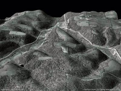


Topographic maps are used for a wide range of applications, from camping, canoeing, hunting and fishing, urban planning, resource development and mapping.
Why?
Given accurately represent the scale, the dimensional characteristics of the earth's surface; This means that each function that is shown on the map represents the exact place where it actually is on the Earth's surface. Topographic maps with detailed information about a particular area. They are an excellent tool for planning and management while helping to keep your outdoor adventures enjoyable and safe.
WHAT IS topographic maps? Topographic map is a detailed and accurate graphic representation of cultural and natural elements on earth.
What type of informationI expect to find on a topographic map?
Topographic map identifies numerous cultural and natural ground features which can be divided into the following categories: Culture: roads, buildings, urban development, boundaries, railways, power transmission line; water: lakes, rivers, streams, swamps, rapids; relief: mountains, valleys, slopes, depressions; Vegetation: a wooded glades, vineyards and orchards; toponymy: place names, water feature names, highway names. See legend on the back of the National Topographic maps for a complete list of all functions and their corresponding symbols. Information along the map borders and on the back side of the map provides valuable information to help you understand and use topographic maps; For example, the map scale and conversion tables, currency legend and map information.